
Road condition surveys you can defend
Potholes graded to ASTM D6433, every defect mapped, from one drive.
Every defect, one click from its frame
Hover a point to see what the camera saw, where it was, and how bad it is.
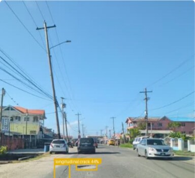
Longitudinal crack 44%
Severity 4, highSTA 0+700
- High (4)
- Medium
- Low
Photos are real captures from RoadSense; the other defects are a sample on the real route. Imagery: Esri, Maxar, Earthstar Geographics.
Survey the road in one drive.
Capture road conditions at traffic speed. RoadSense maps detected defects and generates reports, so your team spends less time collecting and transcribing field notes.
Manual survey
Field inspection at walking / stop-and-go pace
RoadSense
Vehicle capture at normal traffic speed
Field capture time only: estimated at 4 km/h for manual logging versus 40 km/h for vehicle recording, excluding post-drive upload and review.
| Time | Write | State |
|---|---|---|
| 10:42:07 | GPS point | Sent |
| 10:42:08 | GPS point | Sent |
| 10:42:09 | Video chunk, 5 s | Waiting |
| 10:42:09 | GPS point | Waiting |
| 10:42:10 | GPS point | Waiting |
Recording that outlasts the signal
Every GPS fix, five-second video chunk and Start or Stop is saved on the phone first, then sent in order.
- Record video only
- Detection runs later, on the server.
- Sync now
- Sends the queue the moment you’re back in range.
Every road graded per kilometre driven
Each defect counts by its severity, then the total is divided by the distance driven. Add a few and watch the grade move.
High severity
severity 4 to 5
Medium
severity 3
Low
severity 1 to 2
Poor4.0 per km
(3×1 + 2×0 + 1×1) ÷ 1 km = 4.0
0 is Good, under 2 Fair, under 6 Poor, 6 and over Critical: the app’s defaults, set per deployment.
The same pothole gets the same grade
Pothole severity is read off ASTM D6433-18, not judged by whoever drove the road.
| Depth | 100 to 200 mm | 200 to 450 mm | 450 to 750 mm |
|---|---|---|---|
| 13 to 25 mm | Low | Low | Medium |
| 25 to 50 mm | Low | Medium | High |
| Over 50 mm | Medium | Medium | High |
Diameter comes from the box and the camera’s height and pitch. Depth is a band you set, 25 to 50 mm by default.
Draw an area, get its roads
OpenStreetMap supplies every road inside it. Assign each to a surveyor, who starts a mission per road from their own list.
My roads
| Road | Length | Status |
|---|---|---|
| Example Street | 1.2 km | Not started |
| Example Avenue | 0.8 km | In progress |
| Example Road | 2.1 km | Done |
| Example Lane | 0.4 km | Done |
Drive it again, see what changed
A repeat sighting can sit 10 m from the first; two real potholes can be 20 m apart. You set the match radius.
- Still there
- Not detected again
- New
- 5 m
- 10 m
- 15 m
- 25 m
- 50 m
What leaves the car
- A PDF report per mission
- A map of the drive, the defect table and annotated frames.
- A public map
- One link, no account: defects and road grades from public missions.
- A dashboard across projects
- Defects by severity across every mission, worst first.
- A reviewer's final say
- Pause the video, box a defect by hand, and it joins the map and the report.
Deploy in the cloud or on-premises
Whether you need a turnkey cloud workspace today or a sovereign installation behind your ministry or corporate firewall, RoadSense runs where your governance requires.
Deploy in the cloud
Start surveying immediately on Imataka's managed cloud infrastructure — zero server setup, automatic updates, encrypted backups, and instant access for distributed engineering teams.
- Provisioned in minutes with isolated tenant storage
- Automatic model & platform updates
- Encrypted in transit (TLS) and at rest
Deploy on-premises
Run the entire RoadSense stack — AI detection engine, PostGIS database, and web dashboard — inside your own data centre, private VPC, or government network.
- Full data sovereignty: footage and maps never leave your network
- Air-gapped or private intranet operation supported
- Integrates with existing enterprise access & backup policies
Built for data protection compliance
RoadSense secures your survey data from the dashcam to the final report, keeping your organisation compliant with local and international data protection standards.
- Data protection compliance
- Designed around strict data protection principles — including GDPR, the Guyana Data Protection Act, and regional privacy frameworks — with data minimisation and purpose-bound retention.
- Encryption & access controls
- Every video chunk, GPS fix, and report is encrypted in transit and at rest, with role-based permissions so only authorised staff can record, review, or publish missions.
- Complete ownership & retention control
- You own every frame, GPS trace, and report collected. Export or purge raw dashcam video and mission records on your own retention schedule.
- Isolated project & audit records
- Keep internal road condition surveys restricted to your organisation while sharing only approved PDF reports or designated public maps.